
Freeport ZIP Directory Coverage
The official Stephenson County place-to-ZIP list identifies one current code for Freeport. The county ZIP list and the current USPS material both support 61032. They do not support treating every code seen on a third-party list as a Freeport code. This conservative coverage table records what the official sources establish and preserves the gaps rather than filling them with guesses.
| ZIP | Verified area | Postal office evidence | Directory note |
|---|---|---|---|
| 61032 | Freeport is named on the county list | Active Freeport Post Office entry | Confirmed current code; verify each full address |
| 61033 | Not confirmed as current Freeport coverage | No current Freeport office confirmed | Do not use without address-specific USPS proof |
| 61034 | Not confirmed as current Freeport coverage | No current assignment confirmed | Possible legacy or secondary association remains unverified |
The current official sources did not identify a Freeport-only institutional code, a box-only code, or named neighborhoods by ZIP. Nor did they confirm a ZIP split year. A Freeport ZIP code directory should say so. For a real mailing point, use the live USPS address lookup rather than assuming a secondary list is current. A postal result says where mail is routed, not which government taxes, zones, or represents the parcel.
Freeport's Confirmed Postal Code
The Stephenson County ZIP page is the best quick check for the city-name association. Its Freeport row reads 61032. The page is a place-to-code list, not a map of the service area and not a directory of people. It cannot answer whether a parcel sits inside the corporate line.
The source image below documents the county's own listing. It is especially useful when an old note or secondary database associates another 610-prefix code with Freeport.
View the county's current place-to-ZIP list before relying on a code copied from an older source.
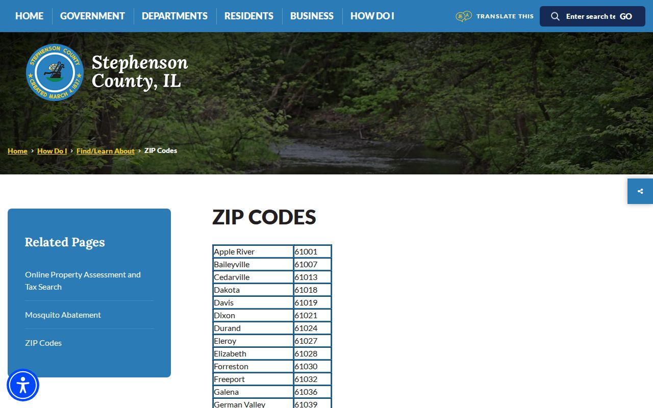
The screenshot establishes the published association, while USPS and parcel records remain the right checks for one complete address.
Note: Record the date of the county page because postal assignments and local web pages can change independently.
Freeport Post Office Evidence
The official Freeport Post Office page supplies the current facility entry, address, telephone number, services, and posted hours. Those details help distinguish a live USPS facility from a historical association. Hours can change, so check the page before a visit.
The successful manifest capture below shows the USPS facility record. The post office page does not list residents and should never be read as proof that all delivery points using Freeport are within city limits.
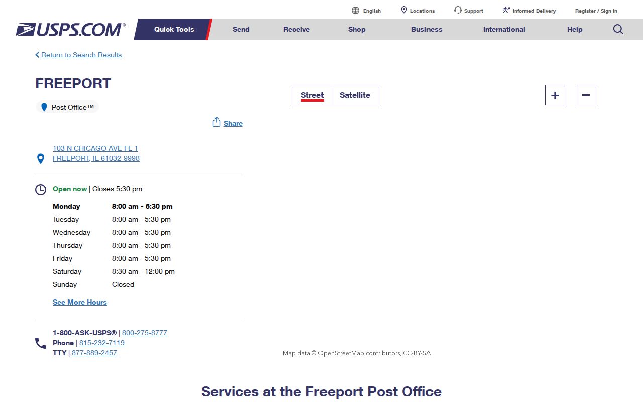
Use the facility entry to confirm the postal source, then validate the exact street and unit through USPS tools.
Freeport ZIP Lookup Terms
Postal terms describe mail routes at different levels. They do not replace the assessor's parcel number, the deed's legal description, or the County Clerk's ward map. Keeping the terms distinct prevents a ZIP code lookup from becoming a false statement about jurisdiction.
- ZIP Code
- A five-digit USPS routing code assigned for mail delivery.
- ZIP+4
- The five-digit code plus four digits that refine a delivery segment. It is not a parcel identifier.
- PO-box ZIP
- A code reserved mainly for post-office boxes. No Freeport-only example was confirmed in the research.
- Unique ZIP
- A code assigned to one high-volume organization. No such Freeport code was verified.
- Carrier route
- A delivery path within a ZIP. It does not define a ward, lot, or city boundary.
Find Freeport Residents by ZIP
The official tools use ZIP in different ways. Illinois voter registration uses it as one required identity check before asking for a street. The Stephenson County assessor form does not show a ZIP field; it uses house range, street, and city. USPS normalizes mail, while the county election maps establish civic geography. Follow the order that matches the record sought.
- Confirm the complete delivery address through USPS. Keep the five-digit code and any ZIP+4 as postal facts.
- For a parcel question, search Devnet wEdge by house number, street, and city. Save the site address and PIN separately.
- For registration, use the Illinois voter lookup only with the person's own required details. The second screen validates street number and a ZIP-populated street name.
- For ward or precinct context, compare the result with the County Clerk election maps.
- If the question becomes street-wide, use the Freeport street directory workflow rather than widening a personal query by ZIP.
A statewide voter file is not an open ZIP directory. Illinois limits the file to registered political committees for bona fide political purposes, and the public self-lookup is designed to confirm one registration. The ZIP code directory therefore uses only the public field sequence, not bulk voter data or copied personal details.
Freeport ZIP Search Fields
The Illinois public lookup is the clearest official example of a ZIP-capable resident check. It asks for identity data first, then validates the street. No compliant sample match was captured, so its output should not be assumed.
| Field | Form | Required | Observed rule |
|---|---|---|---|
| First name | Text | Yes | Letters and spaces observed |
| Last name | Text | Yes | Hyphen and apostrophe accepted |
| Birth date | Text | Yes | Four-digit year; common separators accepted |
| Five Digit Zipcode | Text | Yes | Interface calls for five digits |
| Street number | Second step | Yes | Entered after the first pass |
| Street name | ZIP-based selector | Yes | Choices depend on the ZIP |
The sequence is a useful guard against same-name errors. It also shows why ZIP alone cannot identify a Freeport resident. Use it for a lawful self-check or civic purpose, never as a route to broad personal targeting.
USPS Rules for Freeport ZIPs
The USPS ZIP Code basics state that codes do not necessarily follow municipal boundaries. ZIP+4 adds delivery detail. This is the core geographic caution behind every Freeport ZIP code directory search.
The manifest image below preserves the USPS explanation used for that distinction.
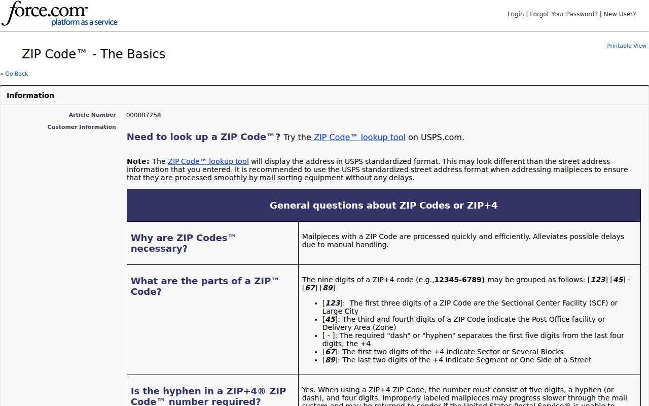
The postal guidance supports address normalization, but a city office or county map must answer a city-limit question.
Freeport Parcel Search Without ZIP
Devnet's inspected parcel form offers Parcel Number, Owner Name, House Number Low and High, Street Name, City, tax codes, tax districts, and property classes. It does not expose a ZIP field. That matters when a Freeport mailing label and a parcel's local jurisdiction differ.
Search the physical site address in the assessor system. Then open WinGIS to check parcel shape and nearby roads. Treat the assessor owner field as an assessment lead, not proof of who lives there or a title ruling. The office and township assessor are the fallbacks if the web form fails.
Note: Mailing address, site address, and legal description may all differ while referring to the same tax record.
Resolve Freeport ZIP Mismatches
A failed ZIP search calls for classification, not repeated guesses. First compare the address as USPS formats it with the site address held by Stephenson County. Check the directional, street suffix, unit, and spelling. A postal city label can be valid for delivery while the parcel sits under a different local taxing or zoning authority. The Devnet City field and the voter form's ZIP field therefore answer different questions.
Next test the date. An old Freeport directory or deed may omit a ZIP because the record predates modern routing, while a later source may preserve a number that changed. The research found no complete Freeport ZIP-assignment history or local change log. USPS Postmaster Finder can supply post-office establishment and discontinuance context, but it is historical evidence, not a list of people or a substitute for current address validation.
Finally, compare the legal and civic layers. A parcel split or merge can change its PIN. Ward and precinct boundaries can change without a postal change. Street renumbering can make two address strings describe the same building. When one source says 61032 and another gives a different code, save both values, their dates, and their stated purpose. Do not silently force agreement.
| Mismatch | Best next check |
|---|---|
| Postal city versus municipal city | USPS result compared with city or county GIS |
| ZIP versus ward or precinct | County Clerk election map |
| Mailing versus site address | Devnet parcel record and PIN |
| Current versus historical address | Directory, deed legal description, map, and source date |
| Unconfirmed 61033 or 61034 claim | Address-specific USPS verification |
This sequence is also the correct fallback when the public tools fail. USPS handles postal questions, the assessment office handles parcel fields, the County Clerk handles election maps, and city or county zoning staff can route a new-address question. A narrow phone or email inquiry with the full address is more useful than asking an office for every person in a ZIP.
Freeport ZIPs Versus City Limits
A Freeport mailing address can fall outside the municipal boundary. Conversely, a parcel question may require a city, township, taxing district, or county source that no postal code can select. Use USPS for delivery, Devnet and WinGIS for the situs and PIN, and the County Clerk's maps for wards and precincts.
Boundary check: Never derive ownership, a ward, a tax district, or city residency from 61032 alone.
If records disagree, label the mismatch: postal versus municipal, mailing versus site, current versus historical, ZIP versus precinct, or a changed street number. The 108 Stephenson Street address later associated with 14 W Stephenson shows why an old address can change without a move. For historical research, cite the ZIP only when the source itself printed one.
No official Freeport annexation conversion table, E911 readdressing table, or complete historical ZIP log was found. Call the relevant city or county mapping office for a disputed location. Preserve both values and their source dates instead of silently choosing one.